Sabah quake occurred at great depth, low risk despite high magnitude, say experts


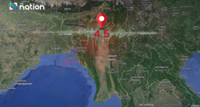
KUALA LUMPUR: Movement and pressure between three major tectonic plates in the subduction zone near Sabah have been identified as the main factors that triggered the strong 6.8-magnitude earthquake in the state.

Universiti Malaysia Terengganu (UMT) Marine Geoscience programme senior lecturer PGeol Dr Muhd Nur Ismail Abdul Rahman said the collision and dynamic interaction between the Indo-Australian, Eurasian and Philippine plates caused a significant build-up of energy within the earth's crust.

He said when the pressure exceeded the rock strength threshold, the stored energy was released abruptly, resulting in a strong tremor measuring 6.8 on the Richter scale.

He noted that although the earthquake registered a large magnitude, its depth of 678km meant the risk of major damage was low.

"Very deep earthquakes can be felt over a wide area but their intensity at the surface is usually weaker. For quakes at such depths, aftershocks are typically smaller and less frequent compared with shallow earthquakes," he told Bernama on Monday (Feb 23).

Muhd Nur Ismail said Sabah remains the most vulnerable area in Malaysia due to its proximity to the subduction zone.

Meanwhile, South-East Asia Disaster Prevention Research Initiative research assistant B. Navakanesh described the phenomenon as a deep slab deformation.

"This means the earthquake occurred on a subducted slab rather than along a fault system. Under high pressure at such depth, the slab can accumulate stress and eventual failure may release massive energy.

"Since it occurred at such depth, most of its energy was absorbed by the mantle and crust. The waves that reached the surface were mainly low-frequency waves that caused less harm. There should be no risk," he said.

Commenting on the likelihood of aftershocks, Navakanesh explained that deep earthquakes often relax faster compared with those that rupture close to the surface.

"Despite our locations appearing close, in reality we are not directly linked. Most of what we experience are intraplate earthquakes, which may be reactivated for various reasons. However, the present-day boundary still poses certain threats, where stress could migrate to local fault systems," he added.

Professor Gs Dr Rosmadi Fauzi from the Universiti Malaya department of geography said the incident was a clear signal that Malaysia is no longer immune to tectonic risks.

The Geographic Information System (GIS) mapping expert said the country's focus must now shift towards identifying potential hazards through mapping technology to support more effective preparedness.

"Disasters do not begin with events but with space. It is time to strengthen geography education in schools to build a society that is more aware of disaster risks and spatial safety," he said.

Earlier, Malaysian Meteorological Department Director-General Dr Mohd Hisham Mohd Anip said the earthquake, centred 49km west of Kudat, posed no tsunami threat but was the strongest to hit the country in the past 11 years. – Bernama


Follow us on our official WhatsApp channel for breaking news alerts and key updates!
Earthquake , Sabah , Geology , MetMalaysia

Next In Nation

Welfare Dept seeking mother of infant found in Butterworth toilet
Armed conflicts, economic weaponisation among key challenges in Wisma Putra's 2026-2030 plan
Committee endorses structured framework to address unregistered temples issue
Sarawak govt to challenge federal laws on petroleum rights
Over 50 schools affected by Sabah floods
Penang cops cripple drug syndicate, seize RM1.2mil in drugs, assets
Dengue cases, deaths more than halved in 2025, says Ahmad Zahid
Sabah floods: Over 70 STPM exam candidates evacuated
Penang MCA sets up panel to help those affected by quit rent hike
UK law firm fails to halt 1MDB proceedings in Malaysia

Others Also Read