
KATHMANDU; Clear skies following the end of Nepal’s monsoon could give way to unsettled weather next week as a low-pressure system over the Bay of Bengal is forecast to intensify into a cyclonic storm, potentially bringing rain to parts of Nepal and snowfall in the high Himalayas.
The Department of Hydrology and Meteorology, in a special post-monsoon weather bulletin issued on Friday, warned that the system could affect Nepal from October 28 to November 1. Meteorologists have urged farmers to protect their ripening paddy crops and trekkers to exercise caution in high-altitude areas.
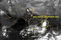
According to the department, a low-pressure area formed over the east-central and adjoining south-eastern Bay of Bengal at 5.45am on Friday. The system is expected to strengthen, move west-north-westwards and develop into a cyclonic storm by Monday before moving towards the coast of northern Andhra Pradesh and adjoining southern Odisha in India.
The department said it was too early to determine the amount of rainfall Nepal could receive or the level of risk, but warned that the weather system could affect agriculture and tourism.
The India Meteorological Department said in a bulletin issued on Saturday that the system was strengthening. It forecast that the low-pressure area would intensify into a depression and then a deep depression on Sunday before developing into a cyclonic storm over the west-central Bay of Bengal by Monday morning.
The system is expected to strengthen further as it moves west-north-westwards, reaching the west-central Bay of Bengal near the Andhra Pradesh coast by Wednesday morning.
Meteorologist Binod Pokharel, who shared a weather analysis on social media, warned of potential weather-related risks across Nepal from October 29 to November 1. Current forecasts indicate rain across much of the country, with heavy downpours possible in some areas.
He said the risk of rainfall would be relatively high on October 30 and 31. The forecast points to possible weather-related risks in Kathmandu and 28 districts across Koshi, Madhesh, Bagmati, Gandaki and Lumbini provinces. Manang also warrants particular attention, he said.
Pokharel noted that the low-pressure system from the Bay of Bengal could interact with an upper-level trough, increasing the likelihood of heavy rainfall.
He urged farmers to monitor local forecasts and make arrangements to protect ripening paddy still standing in fields, as well as harvested crops laid out to dry, from potential damage.
Climate and environment expert Ujjwal Upadhyay also forecast rainfall across the country from October 28 to November 1. He urged farmers to harvest and bring in their crops and recommended suspending trekking in the high Himalayas during the period.
Upadhyay said the weather system could affect Nepal for nearly a week, although that did not necessarily mean continuous rainfall. There could be breaks in the rain, but the weather was unlikely to clear completely, with further showers possible at intervals, he said.
As the system continues to develop, rainfall could intensify, with hail also possible in some places, Upadhyay warned.
Nepal’s monsoon officially withdrew from the country on October 14. Skies cleared across much of the country during Dashain, but the developing system could bring another spell of unsettled weather. - Kathmandu Post/ANN