Technology is increasingly being used to map and understand life beneath the waves, a step that’s proving vital as conservation efforts for coral reefs intensify.
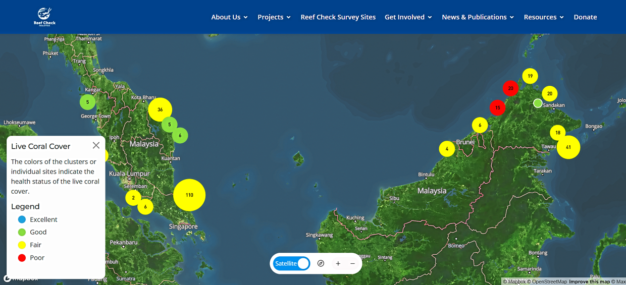
In September, Reef Check Malaysia announced that an interactive map to access details on the health of reefs in Malaysia is now available on its website.
Users can access details such as graphs with location trend analysis to indicate how the health of the coral reefs has changed over a five-year time period. It also has details on species of fish and other sea creatures seen in the area.
“This platform leverages the power of community involvement to gather extensive and diverse data sets. This approach democratises data collection and encourages public participation, fostering a sense of ownership and responsibility towards reef conservation,” Reef Check Malaysia chief operating officer Theresa Ng said in a statement.
The map has a legend to indicate the health status of live coral cover ranging from Excellent to Poor.
When contacted, Ng explained that the data points come from Reef Check’s monitoring surveys on coral reefs, which the NGO has conducted at over 300 sites since 2007. The initiative is supported by a team of volunteer divers from across Malaysia who assist the NGO in collecting data.
She added that the NGO runs a three-day certification programme to train volunteers on identifying fish, invertebrate and substrate for data collection.

“Over the years, we have trained over 1,000 volunteers to assist with data collection. They are mostly avid divers who decided to use their skills to contribute towards reef conservation,” Ng said.
She added that GPS markers or coordinates recorded are used to verify that survey data was collected at the correct reef sites, ensuring its accuracy and authenticity.
“We also consult marine scientists to verify the data before it goes onto the live map. For example, if the live fish count suddenly spikes in an area that usually shows low numbers, the experts will compare it with historical data and conduct further checks to understand what has changed and confirm the findings,” she said.
The map aims to provide timely updates on the reef health indicators as immediate access to current data will allow stakeholders to make informed decisions at a faster rate, ultimately enhancing response time to emerging threats.
According to Ng, there is an impression that “data is not sexy” but she emphasises that data is crucial to identify threats and aid in efforts to mitigate reef damage, guiding both conservation teams and relevant parties in their response. Since the launch of the interactive map, Ng said they have received feedback from various groups including academics and tourism operators.
“Some said the data raised red flags, reflecting their concern over a reef ecosystem that appears to be deteriorating,” she added.
To support conservation efforts using the data on the map, Ng said Reef Check can guide dive site operators and tourist spots on when to temporarily close areas, giving the reefs an opportunity to heal.
Reef Check is a non-profit organisation dedicated to the conservation of tropical coral reefs and temperate kelp forests. Apart from the map, its website also provides educational modules designed for teachers, students and other individuals to learn about marine conservation.
Looking ahead, Ng said it would be exciting to integrate AI and other advanced technologies, such as satellite monitoring, with their on-site dive data.
“This could help us track trends over time and verify the remote data against real-world observations or ‘ground truthing’ to provide more accurate insights for reef conservation,” she said.
Delving deeper
Advanced tech like robots are also being used to aid with coral reef conservation.
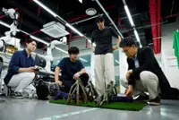
In September, The Straits Times reported the Singapore University of Technology and Design (SUTD) had created an underwater robot that can generate a low-resolution 3D digital twin of coral reefs within minutes. The device, which weighs about 20kg with diving capabilities of up to 30m, is equipped with a system called Maplion to assist operators by capturing visual data of corals and other underwater structures like pipelines, identifying any areas they may have missed to produce a complete 3D map.
According to marine biologist Sam Shu Qin, photographing corals and compiling the footage in a lab is a manual and challenging process, often made more difficult by poor underwater visibility.
“It is a very useful tool if we can successfully map coral transplants and monitor their growth over time at coral restoration sites, or even reef surveys during harmful events like coral bleaching and oil spills in Singapore’s highly sedimented waters,” Sam said in the Straits Times report.
According to Asst Prof Malika Meghjani, who leads the team at SUTD, the robot can also be used to assess ship hulls and monitor the impact of oil spills.
Collective effort
Tech companies are also stepping in to support coral reef conservation by contributing tools and expertise to enhance monitoring and restoration efforts.
In January this year, Huawei launched a Tech4Nature project to monitor and protect coral reefs at the Kisite-Mpunguti Marine Park and Reserve in Kenya.
The project will see the use of underwater cameras, photogrammetry and audio monitoring technologies. AI will also be trained to recognise target species by sight and sound to retrieve real-time data-driven insights. There is also potential for the system to identify boats used for illegal fishing and alert rangers to intervene.
Senior assistant director Adan Kala of Kenya Wildlife Service believes that the technology can help them to protect the ecosystem more effectively.
“The advantage of this technology (is that) it can be deployed in (a) wider area that we couldn’t patrol every single day to get data for day and night for us to make good, informed decisions,” he said in an online statement.
In the same month, Samsung said it was collaborating with nonprofit organisation Seatrees and the University of California San Diego to explore innovative solutions for reef restoration.
The company developed Ocean Mode, a customised camera mode to capture high-quality images of coral reefs while underwater. The company claims that it minimises motion blur and automatically adjusts white balance to enhance clarity and colour accuracy, with the aim of helping researchers receive more precise images for analysis – all to support more effective monitoring and evaluation of coral restoration efforts.
“Design and implementation of coral reef restoration need to be informed by reliable information about what works and what doesn’t. Mobile technologies offer an exciting opportunity to expand access to this information,” Scripps Institution of Oceanography marine ecologist Dr Stuart Sandin said in an online statement.
Improving data analysis
In May, researchers at US-based Woods Hole Oceanographic Institution (WHOI) and the Massachusetts Institute of Technology unveiled SeaSplat, an AI-model to analyse underwater images taken by standard cameras.
The model, powered by Nvidia L40 GPUs, relies on 3D Gaussian splatting (a graphics technique that blends millions of data points to create realistic 3D visuals) to correct water distortions like haze and discolouration, producing more accurate 360-degree reconstructed images.
Researchers believe the model will help ecologists develop a better understanding of coral reefs. According to WHOI associate scientist and model co-creator Yogesh Girdhar, coral reefs may cover only a small portion of the ocean, but they sustain an extraordinary diversity of marine life – hence it is crucial to monitor their ecosystems closely.
“Scientists can use this model to quantify the biodiversity of reefs and detect specific events like coral bleaching or disease,” he said in an online statement.
To collect underwater imagery for training the model, researchers deployed a submersible robot equipped with Nvidia Jetson Orin edge computing technology to assist in navigation and data capture.
So far, SeaSplat has been used to enhance underwater reef images from the US Virgin Islands, the Red Sea, and Curacao. Researchers now aim to make the model more adaptable and scalable for use in any underwater survey or study.