THE removal of legal protection from the Kampung Bohol flood pond has sparked a fresh push from residents to have the site regazetted for “public use”.
Since the pond was degazetted two years ago to allow for a land deal, stakeholders fear the site is now vulnerable to development pressures that could undermine its ability to prevent floods.

Joint Committee to Preserve the Bohol Flood Retention Pond spokesperson Datuk Ng See Eng said silence from the authorities was a major cause for concern.
“We are very concerned that there has been no gazette notice issued. We don’t know what is happening at the site.
“There is no information, no updates and no platform for the public to check on the project’s status.
“The longer this drags on without clarity, the more suspicion it creates.
“This is a flood retention pond, and it must be protected.”
According to Ng, the lack of a public platform for updates has bred suspicion, leaving residents with no way to verify the project’s status.
He insisted that as a vital piece of infrastructure, the pond required the strongest legal protection possible.
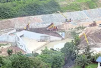
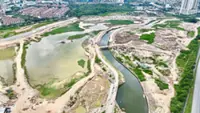
In 2010, the pond was officially gazetted for flood mitigation, covering just under 25ha.
While a 2024 plan aimed to expand the area and boost its capacity, the move has been dogged by controversy.
Reports that land inside the original boundary was being set aside for development have caused alarm, leading to further questions on exactly what is being built on-site.

Evelyne Low, from Kuala Lumpur Residents Action for Sustainable Development (KLRA+SD), said trying to get a straight answer on the regazettement had been an uphill battle.
“There is simply no way to access information on the regazettement.”
She said that the confusion was partly down to red tape: while Kuala Lumpur City Hall’s One Stop Centre deals with zoning, regazettement falls under the land office.
This bureaucratic split has made it difficult for the public to find out if the pond will ever be formally protected again.

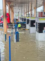
The danger of leaving the pond in legal limbo is very real, according to former Drainage and Irrigation Department (DID) engineer Balachandran Naicker.
He described these basins as a “key line of defence” for the Klang Valley, where rapid development has made flash floods a constant threat.
“They are designed to temporarily store water runoff and release it slowly into drainage systems, reducing the impact on roads and homes.”
Balachandran said such land was typically given protected status to prevent encroachment or development that could reduce capacity.
“These assigned areas are critical. If they are reduced or altered, the system no longer functions as intended.”
Balachandran added that silt and debris could also reduce storage capacity over time if regular maintenance was not done.
While DID is the technical custodian, it works with local authorities and land offices as flood mitigation involves both engineering and land management, he added.
For Balachandran, the Kampung Bohol case is a worrying sign that the city’s flood defences might be slowly compromised. – By BAVANI M and SHALINI RAVINDRAN