JAKARTA: To many Singaporeans, volcanoes are enticing destinations. There is the sunrise over Mount Bromo and the blue flames of Mount Ijen, both in East Java, as well as the crater lake atop Mount Rinjani in Lombok.
However, for many Indonesians, they are both a source of livelihoods – through farming, tourism and guiding – and a constant risk.
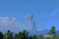
That was the point that the head of national disaster management agency BNPB, Lieutenant-General Suharyanto, sought to make when he addressed disaster officials in Jakarta on May 11, days after two Singaporeans and an Indonesian died following the eruption of Mount Dukono. Seventeen other hikers in the group, including seven Singaporeans, were safely evacuated.
Indonesia, he said, ranks third in the world for disaster risk and fourth for disaster exposure, citing World Bank data. The World Bank report in 2025 describes Indonesia as one of the most disaster-prone countries in the world, exposed to floods, earthquakes and landslides.
The archipelago has abundant natural resources, but “behind that beauty lies the potential threat of disasters that can occur at any time”.
The country is struck so often by natural calamities that it has been described internationally as a “disaster laboratory”, he added.
South-East Asia’s largest country has around 130 active volcanoes – the most in the world – spread across more than 17,000 islands.
Every active volcano has an observation post, Dr Surono, the former head of the government’s volcanology agency, the Centre for Volcanology and Geological Hazard Mitigation (PVMBG), told The Straits Times.
“Whether climbers coordinate with them is another matter,” said Dr Surono, who is one of the country’s most knowledgeable volcanologists and geophysicists.
At these posts, officers monitor earthquakes, gas emissions and movements on the mountain’s surface.
Their findings are analysed by the PVMBG, which assigns one of four alert levels: Normal, Waspada (Alert), Siaga (Standby) and Awas (Highest Alert).
Waspada indicates increased volcanic activity, and usually comes with recommendations for the public to avoid going within a certain distance of the crater. At Siaga, residents within a certain radius are advised to prepare for evacuation, while at Awas, full evacuation is recommended.
The status of each volcano, as well as safety recommendations, can be checked on Magma Indonesia at https://magma.esdm.go.id/, a government website that lists the status of all active volcanoes in the country.
Dr Siti Sumilah Rita Susilawati, who heads PVMBG, said that Mount Dukono has remained at Level II (Waspada) since 2008.
In 2024, the agency widened the no-go zone from 3km to 4km from the crater. Since then, PVMBG has sent recommendations to the North Halmahera administration every two weeks, reminding officials that no activities should take place within that radius.
On April 17, the authorities closed the mountain to visitors and restated that all activities, including hiking, were prohibited within a 4km radius of the Malupang Warirang crater following increased eruptive activity. Mount Dukono remains at Level II (Waspada) alert.
“This volcano is active and an eruption can occur at any time,” Dr Rita said. “If you want to climb a volcano, check first whether it is active and what its status is.”
Mount Dukono, located on Halmahera island in North Maluku province, is one of Indonesia’s most persistently active volcanoes. Between Jan 1 and March 30 in 2026, PVMBG recorded 199 eruptions, with ash columns rising between 50m and 400m above the summit.
Scientists can issue recommendations, but only the local authorities can close access to the volcano.
“Our duty as volcanologists is to provide technical recommendations,” Dr Surono said. “The authority to close the area belongs to the local government because it is their territory.”
Issuing advice and alerts appears straightforward. Enforcing those warnings is more complicated.
Indonesia’s mountains are managed by a patchwork of agencies, including national parks, conservation authorities, forestry offices, district governments, customary communities and state-owned forestry company Perhutani.
Indonesian Mountain Guides Association head Ruslan Budiarto said national parks generally have the strongest controls. Guides and operators are screened, and standard operating procedures (SOPs) are clearly defined.
Outside the national park system, however, supervision is often less consistent. Mount Dukono, for example, is not a national park, and its management is left to the local government.
“We already have the concepts, methods, SOPs and competent personnel,” Ruslan told ST. “But many destinations are simply not ready in terms of governance and systems.”
In Tobelo, the major town closest to the mountain, soldiers told ST that while one main route near the PVMBG office has observation posts, there are numerous other paths up the volcano. Many have no ranger posts or checkpoints.
The problem is not unique to Mount Dukono.
In 2010, Mount Merapi in Central Java erupted, killing more than 350 people and forcing the evacuation of hundreds of thousands from the national park’s vicinity. Despite intensive monitoring and repeated warnings, the scale and speed of the eruption overwhelmed communities and emergency responders.
The disaster showed that even Indonesia’s best-monitored volcano can erupt with devastating consequences.
With so many active volcanoes spread across the archipelago, the country’s challenge is to ensure that scientific warnings are enforced on the ground.
Each volcano requires monitoring equipment, technicians, vehicles and communications systems. Managing tourists safely requires additional investment in multilingual signs, trained rangers, emergency shelters, protective gear and rescue teams.
All of this is costly, especially in remote regions. The same agencies and budgets must also prepare for earthquakes, tsunamis, floods, landslides and forest fires.
This helps explain why safety measures are often uneven, especially in remote areas.
Ruslan said Indonesia has much to learn from Japan and Iceland, where active volcanoes are major tourist attractions but are managed with tighter systems.
After the 2014 eruption of Mount Ontake killed 63 hikers, Japan expanded real-time alerts, strengthened shelters and improved public education. In Iceland, the authorities managing eruptions near Fagradalsfjall have used multilingual warnings, ranger patrols and rapid closures when conditions change.
Indonesia’s scientific capabilities are already strong, experts say. The challenge is to ensure warnings are clear and strictly enforced.
Even when warnings and monitoring systems are working as intended, volcanoes can still catch hikers by surprise.
Ruslan said his association requires guides to use helmets, goggles and masks, and has trained many in volcanic hazards and emergency response. However, it does not have members in all provinces yet, including in North Maluku, home to Mount Dukono, and he said that some younger guides offer high-risk trips without being adequately prepared for them.
Even the most experienced guides cannot predict volcanic activity with certainty.
Muhammad Lingga Abdul Latif, a 25-year-old student mountaineer, said he always researches a mountain thoroughly and consults local residents before climbing.
Earlier in 2026, he and a friend climbed Mount Slamet, an active volcano in Central Java.
When they began the climb, the conditions appeared normal, and the rangers allowed them to proceed.
But when they reached the summit, the weather deteriorated rapidly.
With no mobile signal and unsure of what was happening, they decided to turn back immediately.
On the way down, they encountered rescuers from Basarnas, the national search and rescue agency, who were evacuating climbers and closing the mountain, after its alert status was raised.
“We were very lucky, we were the last group to come down,” he told ST.
Ruslan said guides also encounter visitors who try to bargain over safety restrictions.
With conditions that can change within hours, even long-time local residents do not always see danger coming. Climbing active volcanoes will always carry an element of risk, he stressed.
Yet for many climbers, that risk is hardly a deterrent.
“What I found is that hikers actually have a high level of knowledge about volcanoes, and can accurately identify the risks involved. But that has little effect on their motivation,” said Mr Ruslan. “In fact, the more they know, the more they want to go.” - The Straits Times/ANN