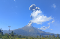
JAKARTA: Indonesian authorities have advised residents living close to Mt Merapi on the island of Java to stay clear of designated danger zones as volcanic activity continues.
Mt Merapi spewed hot clouds in the early hours of Jan 23, Indonesia’s Ministry of Energy and Mineral Resources said in a post on X.
Similar activity was reported on the morning of Jan 19, when six hot cloud avalanches occurred, according to the Antara news agency.
On Jan 21, Merapi erupted, sending clouds of gas into the sky.
A mixture of rock and lava travelled 2km down the volcano’s slopes, said Mr Agus Budi Santoso, head of Indonesia’s Geological Disaster Technology Research and Development Centre (BPPTKG).
Ash also blanketed several nearby villages, he said.
No casualties were reported. But residents living on the slopes of the volcano were advised to stay 7km away from the crater’s mouth, media reports said.
On Jan 22, Indonesian President Joko Widodo officially inaugurated four evacuation routes for communities near Merapi.
“The Muntilan, Keningar, Sukomarmur, and Petung Pakis roads are evacuation routes for Merapi, and they are now completed,” President Jokowi, as he is commonly known, said during his visit to the city of Magelang, as reported by Antara.
The Indonesian government set aside Rp 14.6 trillion (US$930,000 million) in the national budget for road repairs and construction in 2023, a Jakarta Globe report said. For Central Java, the region where Merapi is located, a total of Rp 1.36 trillion has been set aside to repair and build 40 road segments, it added.
Mt Merapi is Indonesia’s most active volcano. The mountain, about 2,970m tall, is around 30km from Yogyakarta.
Around a quarter of a million people live within a 10km radius from the volcano, which sits on fertile soil - largely due to the ash from its eruptions.
During its last major eruption in 2010, more than 300 people were killed and 20,000 displaced.
Merapi’s alert level is currently at the second-highest, according to BPPTKG’s website. - The Straits Times/ANN