



PETALING JAYA: Global warming could have been a significant factor in the devastating floods in Nepal that has claimed hundreds of lives, says climatologist Prof Emeritus Dr Fredolin Tangang.
The Universiti Kebangsaan Malaysia climatologist and Academy of Sciences Malaysia fellow said the risk of such events is increasing in the Himalayan region, making risk mapping and stronger preparedness measures increasingly important.
“Early warning systems are essential in light of the intensification of global warming,” he said, adding that climate change could be the underlying driver.
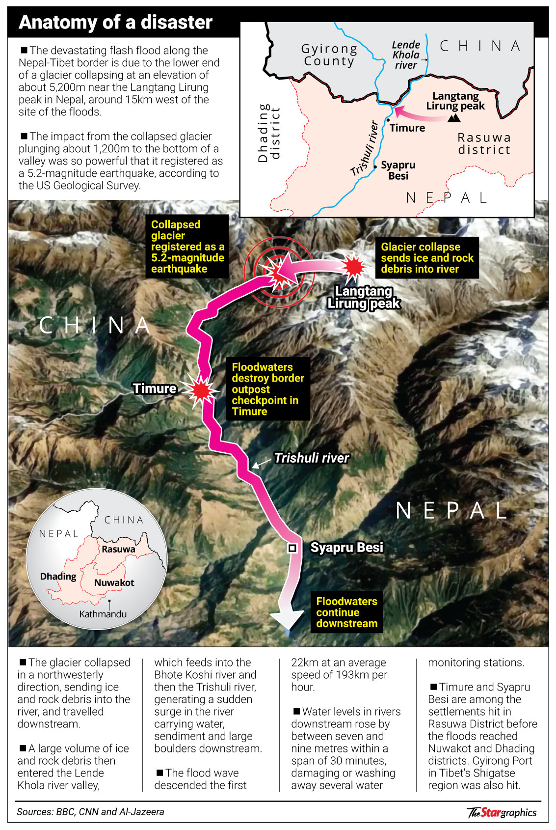
According to an analysis by the United States Geological Survey (USGS), the glacial collapse believed to have triggered the floods generated energy equivalent to a moderate earthquake.
ALSO READ: Anxious families appeal for info on missing loved ones
“Analysis of seismic waves generated by the event indicates a source location in a glaciated mountain cliff on the north side of Langtang Lirung, an approximately 7,200m-tall mountain which is among the 100 tallest mountains in the world,” it said.
The glacial collapse generated energy equivalent to a 5.2-magnitude earthquake, while the resulting debris flow and flood travelled about 100km.
A second seismic event was recorded about three hours later, generating energy equivalent to a 4.2-magnitude earthquake, the USGS added.
A glacial collapse occurs when part of a glacier breaks away and debris rapidly moves downslope.
In this case, the debris contained water and ice that melted rapidly, picking up more material as it moved through existing streams and river channels, creating a fast-moving and far-reaching debris flow and flood laden with boulders and other rubble.
USGS geologists are mapping the inundation boundary of the debris flow and flood using satellite imagery.
Meanwhile, scientists from the International Centre for Integrated Mountain Development and partner institutions in Nepal and China investigating the disaster said it may have been triggered by an ice-rock avalanche from a high-altitude area.
The Kathmandu-based centre said preliminary assessments based on video footage and information from affected areas suggested that a large volume of ice and rock debris may have entered the Lende Khola, a tributary of the Bhote Koshi River.
This would have generated a sudden surge carrying water, sediment and large boulders downstream, it said.
“Hydrological observations indicate the exceptional speed and magnitude of the flood wave. Water levels on the Trishuli River at Galchhi reportedly rose by as much as nine metres within 30 minutes, while levels at Malekhu increased by seven metres over a similar period,” it added.
