IMAGES taken by satellite over three and a half years have shown that fishing activities in the waters off south Penang island mostly take place outside the proposed Penang South Islands project site.
Penang Infrastructure Corporation (PIC) chief executive officer Datuk Seri Farizan Darus said surveyor firm Enviro Land Services has studied 200 satellite images to confirm where fishermen normally fish in the southern waters off Penang island.
“We conducted a three-month manual counting of on-site fisher boats in 2016 when the reclamation proposal was in its infancy, and we found that the earmarked area for the project was not a popular fishing ground.
“However, as the project progressed, we began hearing claims that fishermen actively fished in the PSI site.
“To be sure, we appointed experts to get satellite images and conduct an aerial study to find out exactly where the fishermen fish. The results confirmed the earlier findings,” he said in a statement.
Satellite imagery tech
PIC appointed Enviro, a geospatial expert, and sourced archive PlanetScope satellite images to pinpoint where the local fishermen fished.
The 200 images were captured by PlanetScope’s constellation of hundreds of satellites, which orbit the earth and take pictures daily.
According to Enviro managing director Yip Kit Meng, the 200 images used in the study covered 80% of the area of interest and captured less than 15% cloud cover to ensure a clear view of the south Penang island waters.
“From the images, the positions of individual fishing boats could be clearly located. Enviro then integrated all the locations captured in a single image to indicate the popular fishing locations in south Penang island waters,” he said.
This is believed to be the first time satellite imagery analysis is used to study the spatial extent of a fishing ground in the country.Farizan said the satellite images and Enviro’s findings verified what some fishermen had told the state government and Pusat Perkhidmatan Setempat Nelayan (PPSN) that they usually fish beyond the reclamation footprint.
The findings corroborated with the outcome of an exercise to detect fishermen’s boats by the Malaysian Space Agency (MYSA) using satellite images in April 2021, and January and March this year.
“We have been hearing about fishermen fishing around the kapal simen shipwreck site and all the way to Pulau Kendi. This is reflected in the satellite images we obtained.
“From the findings, we deduced that boats detected within the PSI site, where the water was shallow, were about 12%. The majority of them go further out,” Farizan said.
He said that with larger boats and more powerful engines, which would be provided by the state government under the SIMP scheme, the fishermen would be able to venture even further to catch fish.
“In short, fishing activities will continue even after we have started reclamation works. The sea is vast and the locations where the fishermen normally fish are expected to experience less impact,” he said.
Eyes in the sky
Yip and Farizan both acknowledge that the 200 satellite images could not capture all fishing activities or the movements of the boats.
However, they stress that the available images offer an insight into where the fishermen fished.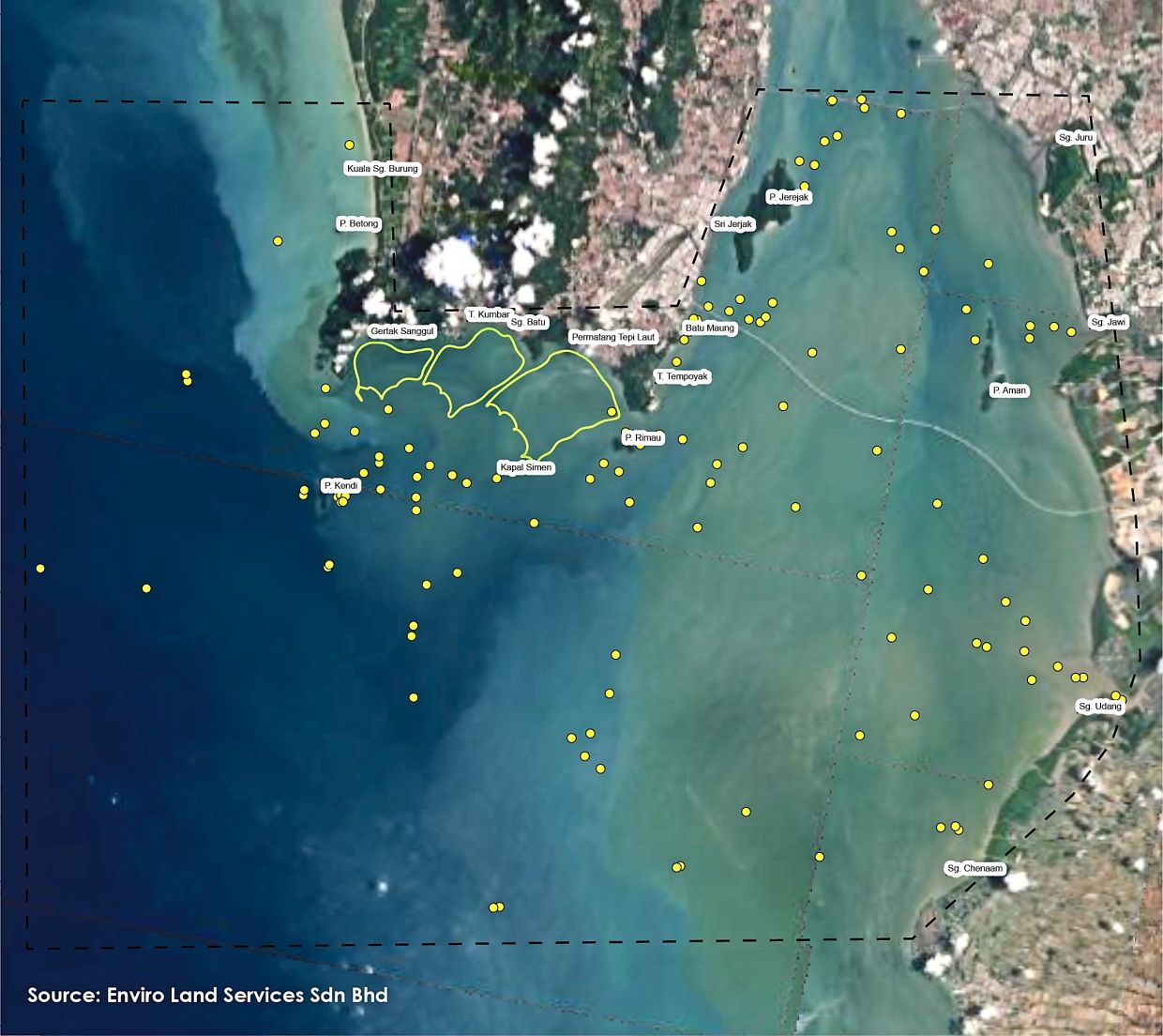
Farizan said despite the shortcomings, they believe the images are reflective of the actual situation.
“The images do not show boat movements at night. But fishermen who fish at night make up a smaller number. They also usually go for fish in deeper areas beyond the PSI site.
“Most of the coastal fishermen involved in the reclamation fish for prawns so their fishing hours are during the day. Their movements would have been captured in these images,” he said.
Farizan said satellite images have proven useful to the project implementation, adding that the state government plans to use satellite imagery technology to monitor reclamation works in the future.
“Thanks to the satellite images, we have information that is useful for the contractor to plan its operations to control vessel movements and prevent pollution.
“They will be helpful for the project’s environmental control measures,” he said, adding that the state government would ensure all necessary measures would be taken to ensure minimal impact on the environment.
Old issues recycled
The PSI reclamation is now pending approval for its Environmental Impact Assessment (EIA) Report and Environmental Management Plan (EMP). The project just concluded its one-month EIA public display in early July.
Farizan said that of late, detractors of the project had re-emerged to attack the project citing environmental and food security concerns.
A memorandum by a network of food producers called Jaringan Pengeluar Makanan was sent to the prime minister earlier last week, demanding that the federal government cancel the PSI project among others.
Farizan said the food security issue against PSI was not new and clarification has been made before that the project would not cause fishermen to lose their livelihood or fishing grounds.
According to 2018 Fisheries Department data, the coastal fish yield in the waters closest to the PSI project only accounted for 1.5% (1,317 tonnes) of Penang’s total marine fisheries and aquaculture yield of 83,881 tonnes that year, he added. The biggest contributor to fish landings in south Penang island were trawlers, whose yield accounted for over 90%, and not coastal fishermen.
Farizan said data from the Fisheries Department did not show a decrease in fish landings in Penang when the Seri Tanjung Pinang 2 reclamation in north Penang island was underway several years ago.
From 2016 to 2020, fish landings increased by 8,125 tonnes compared to the preceding four years.
“A lot of work has been done by expert consultations to conduct studies for the EIA, which includes a fisheries impact assessment (FIA), to ensure we can build an ESG-compliant project with minimal impact on the environment.
“Instead of harping on old issues, we should think of ways to make our fisheries sector more sustainable to deal with climate change and the ever-increasing demand for seafood in and outside Malaysia.
“Under the SIMP, we also want to encourage the local fishermen to go into aquaculture,” he said.
Pro-fishermen measures
Farizan reiterated that the Penang government is not abandoning the fishermen and is making them the first beneficiaries of the development.
“Certain parties often try to portray the state government as the enemy of fishermen. But we hope the public will not be misled.
“Do not deny the many positive initiatives we are putting together to make life better for fishermen through the SIMP scheme and the project’s ecology offset masterplan (PEOM),” he said.
The SIMP offers financial aid in the form of ex-gratia, boats and engines, four new jetties, a navigation channel providing 24-hour access to the sea, job and business opportunities, training and upskilling programmes, home ownership schemes, and education support for fishermen’s children.
The PEOM implements mangrove planting, artificial reef and fish aggregating device deployments, construction of eco-shorelines, the release of fish and prawn fry, provision of funding for marine and fisheries-related studies, and others.
“We have sent nine fishermen for seafarer training and they have obtained their certificates. We are now preparing to deliver the first batch of boats and engines in batches. The ex-gratia payments will also begin once the project is approved.
“The PEOM measures will create new marine habitats for fish and other marine creatures, which is good for the fishermen. We have already started mangrove planting programmes.
“It is unfair that these initiatives are not acknowledged,” he said.
Already a subscriber? Log in
Get 20% OFF The Star Digital Access
Cancel anytime. Ad-free. Unlimited access with perks.