Satellite images to be used in Kemensah landslide investigation


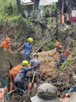
AMPANG: Satellite images will be used to help determine the cause of the landslide in Kemensah Heights, says Deputy Science, Technology and Innovation Minister Datuk Ahmad Amzad Hashim.

He said satellite images taken before and after the incident would be compared in an effort to figure out the cause of the landslide on Friday (Sept 17) night.

Limited time offer:
Just RM5 per month.

Monthly Plan

RM13.90/month
RM5/month

Billed as RM5/month for the 1st 6 months then RM13.90 thereafters.

Annual Plan

RM12.33/month

Billed as RM148.00/year

1 month

Free Trial

For new subscribers only


Cancel anytime. No ads. Auto-renewal. Unlimited access to the web and app. Personalised features. Members rewards.
Follow us on our official WhatsApp channel for breaking news alerts and key updates!
   

Next In Nation

Sabah assembly passes three Bills on last day of meeting
Five-year-old girl in fatal fall from JB condo
Copter tragedy: Cops probing X user for disparaging comments on crash
More arrests to follow in false claims probe involving MB's son, says MACC chief
Former TV host Norjuma charged in four different courts with causing hurt, property damage
EPF Account 3: Most Malaysians appreciate option while others don't wish to touch savings
KKB by-election: EC advice to potential candidates
Defenceless senior citizen gets chilli sauce in face, badly beaten by robber
New mention date set for accused in boyfriend murder case
Copter tragedy: Form an RCI to investigate crash, says Lam Thye

Others Also Read