
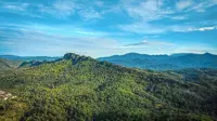
Mandatory guides, daily visitor caps among new rules for Gombak Selangor Quartz Ridge
After a decade-long closure, Selangor’s iconic “Dragon’s Back” is preparing to welcome hikers once again next year, complete with new safety infrastructure and strict crowd controls.
Known as the Gombak Selangor Quartz Ridge (PKGS), the geological marvel in Hulu Kelang stands as the world’s longest pure quartz dyke.
It forms part of the landscape on the outskirts of the capital, stretching some 14km from Kemensah near Zoo Negara to Gombak.
This geological landmark dates back hundreds of millions of years and anchors the Gombak-Hulu Langat Geopark (GHLGp).
Viewed from the air, its long, narrow and jagged quartz rock formations resemble the serrated backbone of a mythical dragon resting amid the lush tropical rainforest.
Its highest point, Bukit Tabur, is 396m above sea level and has long attracted hikers and extreme sports enthusiasts.
Offering a unique combination of challenges and natural beauty, Bukit Tabur presents hikers with steep, rugged cliffs while rewarding them with breathtaking views of the lush greenery surrounding the Klang Gates Dam reservoir and the Kuala Lumpur skyline.
From a technical standpoint, the Bukit Tabur trail is renowned for its demanding terrain, featuring sharp quartz rocks, near-vertical cliffs with gradients approaching 90 degrees, and ravines more than 30m deep in certain sections.
The site’s popularity has drawn thousands of hikers over the years.
However, following several fatal incidents, the authorities closed Bukit Tabur to the public in 2016.
Stricter safety guidelines
During the closure, Selangor government upgraded the recreational area and introduced stricter safety guidelines and sustainable tourism plans to facilitate its eventual reopening.
Selangor Forestry Department (JPNS) deputy director (forest operations) Mohd Nor Firdaus Rahim said the upgrading project comprised two main phases.
Phase One, which cost RM350,000, started in 2025 and is now complete.
To showcase the revamped Bukit Tabur trail, JPNS took Bernama on an expedition along an approximately 2km stretch from the entrance to Checkpoint (CP) 6, which will open to the public during the initial phase.
From the entrance, visitors must climb 150 newly constructed steps to reach CP1, replacing the previous steep, rocky earth trail.
JPNS has also installed handrails and metal steps along sloping sections, as well as safety nets to improve protection for hikers.
Signboards and more comfortable resting platforms are also provided.
Mohd Nor Firdaus, who joined the expedition, said these facilities formed part of tahe department’s efforts to enhance safety along the trail.
“The reopening date is still under discussion by the GHLGp management body, but we expect it to happen as early as next year.
“This will also depend on the readiness of the facilities and a comprehensive safety assessment by the relevant authorities,” he said.
Mohd Nor Firdaus said Phase Two, involving improvements to the trail from CP7 to CP13, was expected to begin soon and finish in 2027, paving the way for the entire trail to reopen.
“For now, public recreational activities at Bukit Tabur and PKGS remain prohibited, except for research, educational and scientific study purposes.
“Those involved must obtain permits from JPNS,” he stressed.
Managing visitors
To safeguard the area’s sustainability and minimise environmental damage upon reopening, Mohd Nor Firdaus said JPNS would implement a stricter visitor management strategy.
“Under this approach, daily visitor numbers will be capped, with entry permitted only within designated time slots.
“The department also plans to make it compulsory for visitors to engage registered forest mountain guides (malim gunung perhutanan), trained in trail navigation, risk management and local flora and fauna identification.
“These trained guides can also promote the principle of ‘take nothing but memories, leave nothing but footprints’.
“Along the trail, hikers will often come across fragments of quartz crystals, which must be protected from being collected or damaged,” he added.
Rescue drills
In terms of emergency preparedness, JPNS will strengthen its response capabilities through simulated rescue exercises along steep ridges.
The drills will involve field personnel, including forestry rangers and forest wardens, who will work alongside the mountain guides.
The department will also collaborate with technical agencies and rescue teams from the Fire and Rescue Department and Ampang Jaya Municipal Council.
Mohd Nor Firdaus said JPNS’ responsibilities had expanded beyond protecting flora and fauna to include preserving ancient geological formations.
“The recognition of GHLGp as a national geopark in 2022 has empowered JPNS to ensure that PKGS is protected against erosion caused by excessive hiking activity, vandalism and the risk of fires along the quartz ridge,” he said.
Urban geopark treasure
GHLGp tourism development manager Mohd Haffez Hanip said the massive geopark covered 112,955ha – spanning across the districts of Gombak and Hulu Langat, thereby falling under several local authorities as well as district and land offices.
He said most of the 31 geosites within the GHLGp area were accessible for recreation, education and conservation.
“This vast area encompasses numerous geological treasures, including the limestone formations of Bukit Takun in Rawang, and sites of historical significance, such as the coal-mining heritage site in Batu Arang and the Sungai Lalang Hot Springs geosite.
“The biological wealth of GHLGp is further enriched by endemic plants, including the merawan kanching tree, found only in the Kanching Forest Reserve in Rawang, as well as the discovery of at least 38 unique amphibian and reptile species along the Gunung Nuang range in Hulu Langat,” said Mohd Haffez.
He added that GHLGp’s distinctive advantage laid in its position as an urban geopark, offering accessible nature-based tourism experiences near the national capital and Kuala Lumpur International Airport (KLIA).
This combination also allows its tourism narrative to encompass a wide range of experiences, from ancient geological history to local cultural heritage.
“However, as most of our geosites have sensitive ecosystems, Tourism Selangor, as the management and coordinating body for GHLGp, must implement low-impact tourism activities such as guided geological trails, forest bathing and birdwatching,” said Mohd Haffez.
“These measures are important to distribute visitor traffic more evenly across the 31 geosites, while preventing excessive tourist congestion at high-risk locations such as Bukit Tabur,” he stressed.
Eyeing Unesco status
GHLGp is now aiming for recognition as a Unesco Global Geopark (UGG).
Mohd Haffez said various initiatives and partnerships had been undertaken as part of efforts to achieve the goal between 2027 and 2028.
Efforts included a collaboration agreement signed with
the Kinabalu Unesco Global Geopark in June 2026 to expand the sharing of expertise and research on best practices in geopark conservation, scientific studies and community development.
To raise awareness among local communities, a pilot geopark school programme was introduced in 2023, involving three primary schools – SK Taman Melawati 2 in Hulu Kelang, SK Dusun Tua in Hulu Langat and SK Batu Arang in Gombak.
The initiative features learning modules, school galleries and field trips to introduce pupils to the geological and natural heritage of their surroundings.
Mohd Haffez said plans were also underway to develop information centres to provide visitors with an introduction to the geopark.
These include the proposed GHLGp Exploration Centre as a one-stop centre in Taman Melawati and a gallery in Hulu Langat, alongside satellite galleries such as the Batu Arang Gallery managed by Selayang Municipal Council.
“We have also established the local community host programme (HKSS).
“It is aimed at training residents and Orang Asli communities living near the geosites to venture into homestay services, handicrafts and the marketing of small and medium enterprise products, such as kuih jongkong, under the geo-products label to enhance their value.
“We are doing all this to ensure the geopark thrives alongside communities equipped with skills through HKSS and the forest mountain guide programme spearheaded by JPNS.
“Ultimately, we hope to nurture a generation with a ‘guardian spirit’ to help protect these geological treasures.”
Quartz ridge’s formation
Beyond community engagement, preserving the site’s scientific value remains central to its Unesco bid.
Universiti Kebangsaan Malaysia (UKM) Institute for Environment and Development Geological Heritage and Landscape Research programme head Assoc Prof Dr Tanot Unjah said PKGS was formed through the collision of tectonic plates between 210 and 220 million years ago.
Over millions of years, weathering and erosion gradually removed the surrounding rock and soil, exposing the white quartz formation as a massive, near-vertical wall measuring between 50m and 200m thick.
“This geological uniqueness has also enriched the surrounding ecosystem.
“The PKGS area is recorded as a habitat for at least five endemic plant species, including Ilex maingayi, a rare tree species from the holly family that is now threatened with extinction.
“The area also provides refuge for wildlife such as the Sumatran serow, which faces the threat of illegal hunting,” said Tanot, who is also the scientific adviser to GHLGp.
She added that PKGS played a critical role in the hydrological system as part of the Klang Gates Dam catchment area, which supplies water to millions of people in the Klang Valley.