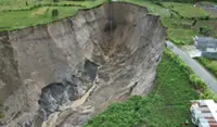
JAKARTA: A massive cavity spanning more than 30,000 square metres, roughly equivalent to four to five football fields and reaching a depth of up to 100m in Central Aceh, is the result of landslides rather than a sinkhole, Indonesia’s National Research and Innovation Agency (BRIN) said.
Head of BRIN’s Geological Disaster Research Centre Adrin Tohari said the expanding hole in Kampung Pondok Balik has drawn public concern due to its increasing size and depth with some residents and media reports likening it to sinkholes seen elsewhere.
However, he said the geological structure of the area does not support a classic sinkhole formation, which typically occurs in limestone terrain.
"What happened in Central Aceh is actually a landslide phenomenon, not a sinkhole. The tuff layer is not dense and has low strength, making it easily eroded and prone to collapse,” he said as quoted in a statement issued by BRIN, on Saturday (Feb 21).
Adrin explained that the area consists of pyroclastic flow deposits in the form of tuff from past activities of Mount Geurendong, which is no longer active, and the material is geologically young and has not undergone full compaction, making it fragile and susceptible to failure.
He noted that satellite imagery from Google Earth since 2010 had already shown a small valley or canyon at the site and over time, erosion and repeated landslides widened and elongated the depression until it formed the large cavity visible on Sunday (Feb 22).
He said a 6.2-magnitude earthquake that struck Central Aceh in 2013 likely weakened the slope structure, while heavy rainfall further accelerated the process, as the fragile tuff rock becomes easily saturated and loses cohesion.
Adrin stressed that the phenomenon did not occur suddenly but developed over tens to hundreds of years with earthquakes and rainfall acting as accelerating factors in the natural formation of the valley or canyon.
He noted that similar geological conditions can be found in other regions with young volcanic rock formations, citing Ngarai Sianok in West Sumatra, which formed through long-term geological processes linked to tectonic activity along the Great Sumatran Fault.
He called for improved mitigation efforts, including stricter control of surface water flow, clear hazard zoning and the installation of landslide early warning systems, while urging residents to stay alert to early signs such as ground cracks or small-scale subsidence.
"Landslide vulnerability maps already exist, but they need to be updated following this incident to improve accuracy and operational use. The priority now is to understand the process and immediately implement mitigation measures to prevent casualties,” he added. — Bernama