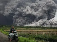
JAKARTA: Mount Ibu in North Maluku erupted on Wednesday (March 26), spewing hot lava and a towering column of smoke and ash 1,000m into the sky, an official said.
The volcano, located on Halmahera Island, erupted at 9:45pm eastern Indonesia time, releasing hot glowing lava 300m above the summit.
An official at Mount Ibu's monitoring post, Axl Roeroe, said the volcano also spewed a thick grey ash column that travelled eastward and reached a height 2,300m above sea level.
"Seismic data recorded a maximum amplitude of 14mm, with the eruption lasting one minute and 15 seconds," Axl said on Wednesday, as reported by Kompas.
He said the noise of the eruption was heard at the observation post, located in Gam Ici village, around 9km from the volcano.
There has been no new evacuation order, but visitors and villagers have been told to vacate a zone 4 to 5km from the peak. Authorities also urged people to wear face masks and protective goggles in case of volcanic ash rain.
Authorities have maintained Mount Ibu's status at Level III siaga (watch), the second-highest of the four-tier volcano alert system. Mount Ibu is one of the most active volcanoes in the country, erupting around 1,000 times in January alone.
A massive eruption that took place on Jan 16 prompted the National Disaster Mitigation Agency (BNPB) to evacuate dozens of residents from six villages located within a radius of 6km from the summit.
The day before, Mount Ile Lewotolok in Lembata regency, East Nusa Tenggara (NTT), erupted 179 times, emitting loud growling and booming sounds. An official at the volcano monitoring post, Stanislaus Ara Kian, said the eruptions lasted between 27 and 225 seconds, with seismic readings ranging from 17 to 38mm
"The mountain emitted white-gray ash columns that soared 200-300m above the summit. Volcanic debris was also observed within a 500-metre radius of the eruption centre," he said on Wednesday.
Stanislaus said Mount Raung's status remained at Level II waspada (advisory) and urged the public to avoid all activities within a 25km radius of the summit.
Authorities also advised residents of the villages of Jantona, Lamatokan, Todanara, and Amakaka – located at the foot of the 1,523-metre volcano – to remain alert for falling rocks and volcanic landslides.
Residents living near rivers originating from Mount Ile Lewotolok were also urged to stay vigilant for possible lahar flows, especially given that the rainy season is still ongoing.
Last week, a massive eruption also occurred at Mount Lewotobi Laki-laki in NTT, prompting authorities to raise the alert status to the highest level and evacuate around 5,000 people from villages within 8km of the summit.
Domestic and international airlines were forced to cancel dozens of flights to the nearby island of Bali as the volcano released ash clouds soaring more than 8km into the sky.
The eruption also caused a local farmer to suffer severe burns. He passed away on Thursday after receiving medical treatment. - The Jakarta Post/ANN