A hiker followed Google Maps and ended up stranded on a steep and dangerous cliffside in Canada, rescuers say.
He had tried to climb Mount Fromme, one of the North Shore Mountains north of Vancouver, British Columbia, on Saturday, Nov 4, North Shore Rescue said in a Facebook post.
Rescuers believe the hiker followed a trail on Google Maps that doesn’t exist, according to the post. It’s the third time rescuers have pulled someone from the area, most recently in September.
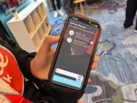
A photo of the app shows the trail leading north of Fromme toward Kennedy Falls. Rescuers contacted Google to get the nonexistent trail removed from the app, which has now been done, officials said in a Nov 6 post.
McClatchy News reached out to Google on Nov 6 and didn’t get an immediate response.
“To be clear, the area in question has no trails and is very steep with many cliff bands throughout,” rescuers said. Photos show the dramatically steep cliff where the hiker was trapped.
In the comments, several people said they had submitted feedback on the app notifying others of previous rescues and a death, and that there’s no trail to speak of in the area.
North Shore Rescue placed warning signs in the area to keep more hikers from following the trail on Google Maps and ending up stranded. A photo in the comments shows the sign says “wrong way, dangerous cliffs”.
What’s more, the area is “clearly dangerous, as it was the site of a previous fatality”, rescuers said.
A “low cloud ceiling” hanging over the dense woods on Saturday made the rescue all that more challenging, rescuers said. The team used a rope rescue as well as helicopter rescue teams.
The hiker did not have any light to shine through the dense tree canopy, so the helicopter team couldn’t see him from the air, officials said. Rescuers hoisted two helicopter rescue technicians down about 330 feet into the trees where they thought the hiker was, and the team then navigated the terrain on a roped belay.
They found the hiker, got him into a harness and lowered him to safety where they could all be removed by the helicopter – “just before the clouds closed in and would have otherwise prevented helicopter access”, officials said.
Rescuers urged hikers not to rely on programs like Google Maps alone when it comes to navigating the wilderness. For those who do use phone-based navigation apps, officials recommended ones specifically designed for the outdoors that are pre-loaded with “an appropriate wilderness topo map for the area”, such as CalTopo or Gaia.
While it’s a good idea to use “good old fashioned paper map and compass”, those relying on a phone for navigation should bring an extra charged external battery.
“Mapping programs can quickly drain your phone’s battery, especially in the cold,” officials said.
Additional research beyond Google Maps would have shown there are no trails in the area, officials said. The hiker also had minimal gear, inappropriate footwear for rough terrain and no flashlight – which made it impossible to find him from the helicopter, especially with all the cloud cover, officials said.
What to do if you get lost while hiking
If you think you’re getting lost, experts say it’s best to stop where you are and not panic. You should go over how you got to that point and if you’re able to see any landmarks around.
“Do not move at all until you have a specific reason to take a step,” officials with the US Forest Service said.
You should come up with a plan but stay put unless you are “very, very confident in the route”.
There are steps hikers can take to avoid getting lost and be better prepared for the unexpected:
-
Have more than enough food and water with you.
-
Take a compass that you know how to use, or have a GPS device on hand.
-
Don’t rely solely on your cellphone. It probably won’t work because of a lack of signal or a depleted battery.
-
Study the terrain and your route, and you should know how you’ll return.
-
Have the right clothing. Sturdy hiking boots and layers can help you be prepared for rapidly changing weather.
-
Pack a blanket, flashlight and matches.
-
Check with a local ranger for special warnings. They can tell you about “fires in the area, bear sightings, flooding, trail or road closures”. – The Charlotte Observer/Tribune News Service
Already a subscriber? Log in
Get 20% OFF The Star Digital Access
Cancel anytime. Ad-free. Unlimited access with perks.