PETALING JAYA: A plan has begun to map out the risks of slope failures on state roads in Selangor to avoid a repeat of the Batang Kali landslide.
The Selangor Public Works Department (JKR) director Lokman Nasir said that Selangor JKR, with the collaboration of the department’s slope engineering branch, would apply for a budget from the Federal Government to implement landslide hazard and risk mapping for all state roads in Selangor next year.
This came about following the Dec 16 disaster which happened on a site not under JKR’s radar.
A landslide hazard and risk map would allow the authorities to detect hotspots and plan for mitigation and emergency responses accordingly.
ALSO READ: Danger slopes under close watch
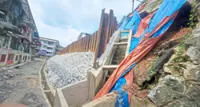
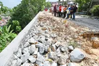
Referring to the Batang Kali landslide area, which involved a state road, Lokman said that as of now, no work would be done at the area for at least a month until all studies and investigations were completed.
“The Jalan Batang Kali-Genting Highland road is closed for now,” he said, adding that further surveying works and soil investigations were being carried out.
He also pointed out that plans to widen the Batang Kali road, as mentioned by the Selangor Mentri Besar Datuk Seri Amirudin Shari, was meant for diversion of light vehicles such as motorcycles.
This, he said, would depend on the outcome of the monitoring of the stability of the slope.
“The monitoring and analysis for the road and the landslide area is expected to take between two weeks and a month for us to collect all the necessary data before we can decide on the best course of action.
“Until then, the affected area will not be touched,” said Lokman.
He was referring to a statement by Amirudin on Dec 25 that widening the road would help 4,000 to 5,000 residents in Hulu Selangor, especially those who work in Genting Highlands.
JKR deputy director-general Datuk Ahmad Redza Ghulam Rasool said the mapping of state roads for possibility of slope failures was being done in stages, even before the landslide happened.
For instance, he noted that Penang was one of the states that they worked with on landslide hazard and risk mapping of state roads.
He explained that the mapping was being done for slopes along road reserves and did not include private land.
“We have done this for slopes along federal roads in the peninsula,” he added.
Ahmad Redza said there were 1,045 slopes along federal routes in the peninsula currently under JKR’s radar.
These had been identified as “very high risk slopes” with Pahang, Perak, Kelantan and Selangor topping the list with the most number of hotspots.
Already a subscriber? Log in
Get 20% OFF The Star Digital Access
Cancel anytime. Ad-free. Unlimited access with perks.