SOUTH TAPANULI, Indonesia: Indonesian Reliwati Siregar gestured angrily at deforestation around her home on the island of Sumatra, where landslides and floods brought by a tropical storm killed more than 700 people in its deadliest disaster since a cataclysmic tsunami in 2004.
"Mischievous hands cut down trees... they don't care about the forests, and now we're paying the price," Siregar said at a temporary shelter near her home in Tapanuli, the worst-hit area, with about a quarter of the death toll, government data shows.
The landslides buried homes and crippled rescue and relief efforts, while floodwaters washed ashore dozens of logs, Siregar said.
"The rain did cause the flood, but it's impossible for it to sweep away this much wood," the 62-year-old added, her voice rising in disgust. "Those raindrops do not cause wood to fall."
Large death toll
Environmental experts and regional leaders said the tropical storm in the Malacca Strait that hit Indonesia, Malaysia, and Thailand last week, killing more than 800 people, was just one of many worsened by climate change.
But deforestation in Sumatra led to a disproportionately deadly toll, they said.
"Yes, there were cyclonic factors, but if our forests were well-preserved... it would not have been this terrible," Gus Irawan Pasaribu, a local government leader in Tapanuli, told Reuters by telephone.
Pasaribu said he had already protested to the forestry ministry over licences issued for the use of forest area for projects, but it ignored his pleas.
Indonesia's forestry and environment ministries did not reply to Reuters requests for comment.
Media said the attorney general's office is leading a task force to check if illegal activities contributed to the disaster, and that the environment ministry would query eight companies in industries such as logging, mining and palm plantations, after logs washed ashore in some areas of Sumatra.
They did not identify the companies or projects.
Masinton Pasaribu, another local government official in Tapanuli, blamed the clearing of natural forests to make way for palm plantations, which yield palm oil, one of Indonesia's main exports.
Authorities in the archipelago, home to many dense tropical forests, have looked to reverse some of the destruction but lean heavily on its vast natural resources to fuel economic growth.
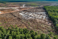
Monitoring group Global Forest Watch says North Sumatra lost 1.6 million hectares of tree cover over the period from 2001 to 2024, or the equivalent of 28 per cent of the tree-covered area.
From 2001 to 2024, Sumatra as a whole has lost 4.4 million hectares (11 million acres) of forest, an area bigger than Switzerland, said David Gaveau, founder of deforestation monitor Nusantara Atlas. "This is the island of Indonesia that has had the most deforestation," he said, adding that global warming was the biggest factor in the deadly floods, though deforestation had a secondary role.
Upstream projects
Environment-focussed group JATAM said its analysis of satellite imagery showed construction for the China-funded 510MW Batang Toru hydropower plant, planned to begin operating in 2026, contributed to the destruction.
"This situation can no longer be explained merely by the narrative of 'extreme weather,' but must be understood as a direct consequence of upstream ecosystem and watershed destruction by extractive industries," it said in a statement.
Reuters could not reach North Sumatra Hydro Energy, which runs the plant, to seek comment. Its parent, China's SDIC Power Holdings, did not immediately respond to a request for comment.
Another environment-focused non-government group, Walhi, sought revocation of a government permits for the hydropower plant in a 2018 lawsuit in a state administrative court, but the court rejected the suit in 2019, media say.
"This disaster was caused not only by natural factors but also ecological factors, namely mismanagement of natural resources by the government," Walhi said.
JATAM said legal permits to convert forests into extraction zones covered about 54,000 hectares, a majority of them for mining.
Among the permit holders is PT Agincourt Resources, which operates the Martabe gold mine in the Batang Toru ecosystem.
In a statement to Reuters it said making a direct link between the floods and the mine's operations was "a premature and inaccurate conclusion".
Instead, it pointed to extreme weather, the overflowing river, and a blockage of logs at one point in its course. "Usually just a few... but now, there's more than ever," said Yusneli, 43, a resident of the West Sumatran city of Padang, who goes by one name, as she described the alarm caused by the number of logs washing ashore. - Reuters