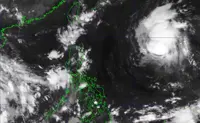
MANILA: Tropical Storm Queenie has maintained its strength while moving over the Philippine Sea east of extreme northern Luzon, the state weather bureau reported on Friday.
Based on the 5 a.m. Philippine Atmospheric, Geophysical, and Astronomical Services Administration (Pagasa) weather bulletin, Queenie is still carrying a maximum sustained wind speed of 75 kilometres per hour (kph) near the centre and gustiness of up to 90 kph.
Located 1,065 kilometres east of Extreme Northern Luzon, the tropical storm is currently moving northwestward at 20 kph.
No tropical cyclone wind signal is currently hoisted in any part of the country, Pagasa said.
Queenie is expected to move generally west-northwestward until this Friday afternoon before moving northwestward on Saturday morning.
“By tomorrow afternoon, the tropical cyclone is forecast to decelerate as it begins to turn from northwestward to northeastward,” Pagasa said.
The weather bureau also noted that the tropical storm will gradually intensify and may reach the “typhoon” category by Sunday.
Queenie is forecast to exit the Philippine area of responsibility (PAR) between Sunday afternoon and Monday early morning.
Outside the PAR, the cyclone will accelerate as it heads northeast, said Pagasa. - Inquirer/ANN