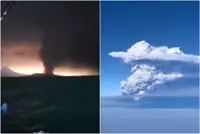
JAKARTA (Bernama): The Sunda Strait remains safe from a tsunami threat amid ongoing activity at Mount Anak Krakatau, with no tsunami detected as authorities continue round-the-clock monitoring.
The volcano is located in the strait, between the Indonesian islands of Java and Sumatra.
Indonesia’s Meteorology, Climatology and Geophysics Agency (BMKG) said its high-frequency (HF) radar monitoring placed the probability of a tsunami in the Sunda Strait in the low category as of 8 am Monday.
"The Sunda Strait crossing route remains in safe condition,” the agency said in a statement on Monday.
BMKG Acting Deputy for Geophysics Ardhasena Sopaheluwakan said monitoring at 20 tsunami gauges around the strait also showed no unusual changes in sea level that would indicate a tsunami.
While the gauges showed no indication of a tsunami, he said BMKG’s other instruments recorded increased volcanic lightning and geomagnetic disturbances between midnight and 4 am, although both were less intense than during the first eruption on Sept 4.
On sea conditions, BMKG Acting Deputy for Meteorology Andri Ramdhani said surface currents were predominantly moving southwest towards the Indian Ocean at between 0.4 and 0.9 knots, with waves measuring between 0.3 and 1.2 metres.
Looking ahead, he said wave heights in the Sunda Strait were forecast to range between 0.5 and 2.0 metres from Sept 8 to 13, with generally clear to partly cloudy conditions expected around Anak Krakatau and the strait.
Andri said BMKG had issued 39 Significant Meteorological Information (SIGMET) advisories for aviation since the first eruption on Sept 4, with the latest showing ash reaching 15,000 feet (4,572 metres) and moving westward towards Sumatra and the Indian Ocean at 15 knots.
"Based on an analysis of Himawari-9 satellite imagery at 9 am, the wind pattern generally pushed Mount Anak Krakatau’s volcanic ash westward,” he said. -- Bernama