
HANOI: Typhoon Narra, designated as Storm No.4 in Vietnam, stalled off the northern coast early Monday (Aug 24), dumping torrential rain that pushed several rivers to their highest flood-alert levels, killed at least one person and damaged more than 4,000 homes in the northern province of Lang Son.
At 4am, the storm's centre sat over the Gulf of Tonkin about 140km east of Quang Ninh province, packing sustained winds of 75-88km/h and gusts as strong as 103-117km/h, the National Centre for Hydro-Meteorological Forecasting said.
The system had barely moved in the previous six hours. Forecasters expect it to drift slowly east, then northeast, over the Gulf of Tonkin before making landfall in China's Guangxi region
Wind gusts as strong as level 11 (103-117km/h) were recorded on the island of Bach Long Vi while rainfall since Aug 21 topped 500mm in parts of Quang Ninh and 520mm in Lang Son, saturating soil across the northeast and raising the risk of flash floods and landslides in mountainous areas, the forecasting centre said.
In the northern province of Bac Ninh, authorities issued back-to-back emergency flood warnings after water on the Thuong River breached the highest danger threshold, Level 3, just after midnight, and the Cau River exceeded Level 2 by dawn.
The Thuong River was measured at 6.32m – 2cm above the Level 3 mark – at the Phu Lang Thuong station, with a peak of roughly 7.1m forecast by early Tuesday, according to the provincial hydro-meteorological station.
The Cau River was expected to keep rising to as high as 7.9m over the following day.
The province's civil defence command ordered local authorities to inspect riverside settlements, prepare to evacuate residents and step up dike patrols under the standard 'four on-site' emergency response model.
In neighbouring Thai Nguyen Province, the Cau River also exceeded its Level 2 threshold at the Gia Bay gauge station, prompting provincial forecasters to raise the flood-risk warning to Level 2 and caution of possible flash floods, landslides and urban waterlogging as rain continues.
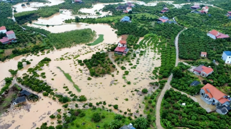
The mountainous province of Lang Son has been hit hardest. As of Aug 23, one person had died after a landslide caused a house to collapse, and more than 4,000 homes and outbuildings had been damaged or flooded, provincial authorities said.
The storm also destroyed or damaged roughly 2,680ha of crops and forest, washed out or flooded more than 900 points on local roads, and left more than 1,300 small businesses unable to operate.
In the communes of That Khe and Trang Dinh, about 2,000 households had their homes flooded, and many families were forced to evacuate. Residents were still moving by boat through submerged neighbourhoods on Sunday even as rainfall eased, though water levels had not receded.
"The water rose so high I couldn't even cook," said Nguyen Thi Bac, a resident of That Khe, who said she has relied on relatives, local authorities and aid groups for daily supplies while she waits for the floodwater to recede.
The Vietnam Red Cross's Lang Son chapter distributed 850 emergency aid packages to affected households across seven communes and wards. Two guesthouses run by the provincial police – with a combined capacity of more than 100 rooms – opened their doors free of charge overnight for displaced residents; more than half the rooms filled within hours.
Dinh Huu Hoc, vice chairman of the Provincial People's Committee of Lang Son, urged local officials to relocate residents from danger zones and keep emergency forces and supplies stationed in flood- and landslide-prone areas that risk being cut off.
Following an Aug 21 directive from the prime minister, the Ministry of Construction ordered agencies across the road, rail, maritime and aviation sectors to prepare for post-storm flooding.
Road crews were told to clear landslides and washouts on key highways and guard flooded fords and river crossings; rail operators to step up patrols at vulnerable bridges and embankments; and maritime authorities to guide vessels to safe anchorage and keep rescue teams on standby. Airlines were told to adjust flight schedules as needed for safety.
The national forecasting centre placed the Gulf of Tonkin under its Level 3 disaster-risk warning, with flash-flood and landslide risk in northern provinces rated Level 1 to 2, rising to Level 2 in Lang Son and Quang Ninh. — Vietnam News/ANN