


PANTAI CUNANG, a once- tranquil coastal retreat in Kuala Langat, Selangor, is in need of help.
The 2004 tsunami created this sandbank along the coastline, forming the beach adjacent to the Kampung Orang Asli Tanjung Sepat’s mangrove forest.
Known for its fine sand, the beach – which was formerly populated by mangroves – was named by the Orang Asli for its tranquility.
Cunang means peaceful in the Mah Meri language.
Today, Pantai Cunang presents a starkly different scene.
Visitors are greeted by a disappointing sight of uprooted trees, damaged infrastructure, an uneven shore, and rubbish strewn about.
It rarely gets outsiders visiting due to its poor state.
This is despite being located next to Pantai Tanjung Sepat, which is known for its Lover’s Bridge – a popular local attraction.
The Mah Meri – an indigenous community living near Pantai Cunang – are keenly feeling the decline, which is caused by a combination of factors, namely coastal erosion caused by high tides, strong winds and rising sea levels.
The fishing community, when met, said they were living in fear of one day losing their homes and livelihoods.
Villager Sarimah Jamil said the community enjoyed the white sandy beach after the tsunami.
She said the state government saw potential in the beach and allocated funds to build public facilities.
“Toilets, gazebos, futsal court, carpark and a communal hall were built sometime around 2010.
“The beach was maintained so well that Pantai Cunang was named ‘Pantai Angkat Terbaik’ in 2015 under the state adopted beach programme.
“We managed to get some income from selling things to visitors who came to enjoy the beach.
“But the landscape began changing a few years ago, and it has since worsened,” she said, adding that a 290m stretch of the beach had been badly affected.
The villagers also told StarMetro that they fear continuing erosion will affect the mangrove forest, which in turn will affect their fishing activities.
State keeping tabs
The state government is aware of the situation and has approved a project to address issues in Pantai Cunang.
Selangor infrastructure and agriculture committee chairman Datuk Izham Hashim said the Drainage and Irrigation Department (DID) had initiated a RM7.9mil project to build and upgrade coastal barriers, address erosion at Pantai Cunang and Pantai Tanjung Sepat in Kuala Langat.
The project, which began on June 21 last year, is slated for completion by July 21, 2026.
Kampung Orang Asli Tanjung Sepat village chief Nasir Mijin said state authorities had briefed residents’ representatives in the surrounding area on the project.
“The situation at the beach is getting worse.
“We hope the state and experts will do something to stop the situation from worsening,” he said.
Coastal erosion
DID director-general Datuk Mohamad Radzi Abdul Talib said Pantai Cunang had been facing worsening coastal erosion since the high-tide phenomena linked to rising sea levels was detected in September 2016.
He said rising sea levels, driven by global warming and climate change, and combined with storms and strong winds, had resulted in waves of greater intensity.
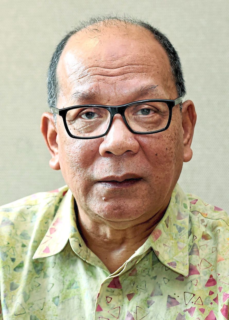
“This caused significant erosion, submerging and flattening of coastal areas and reduction of land space,” he said.
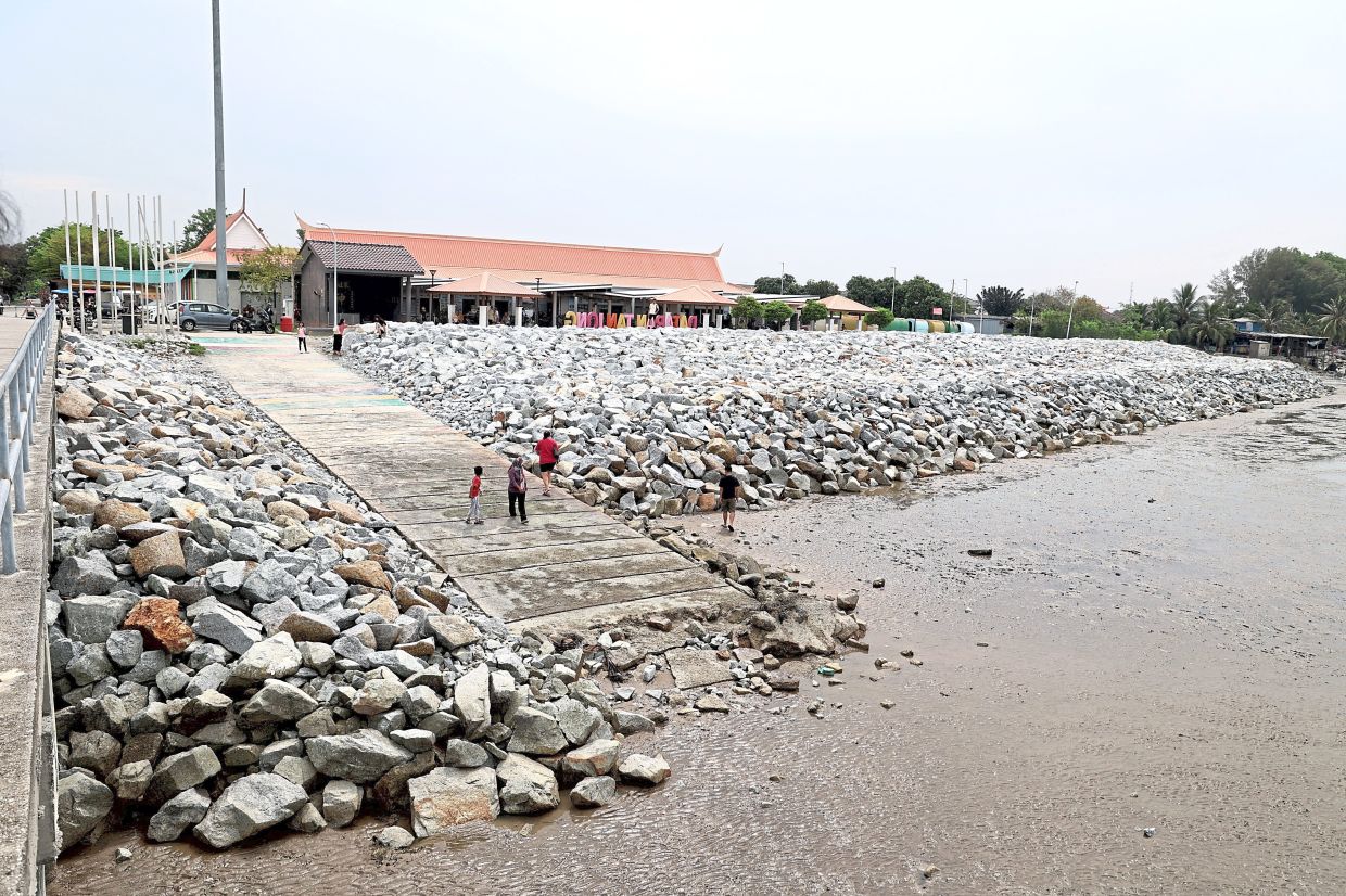
Mohamad Radzi said the DID project included the construction of a 375m-long rock revetment structure, two 50m-long training walls and 290m beach nourishment at Pantai Cunang as well as a 220m-rock revetment structure at Tanjung Sepat. (see graphic)
“The project aims to address coastal erosion and flooding in Pantai Cunang and Pantai Tanjung Sepat,” he said.
The rock revetments were designed to absorb wave energy and reduce erosion to protect fishing settlements, access roads and coastal infrastructure, he added.
“The training walls will act as hydrodynamic control structures, controlling the movement of sand sediments and stabilising replenished sand along the beaches,” said Mohamad Radzi.
“This will extend the lifespan of the beach protection, reduce risks from large waves, and improve safety for fishermen navigating the estuary.”

He said coastal stabilisation through beach nourishment – the practice of restoring a degraded coast by dredging and depositing compatible sediment – would provide a wider and safer coastal zone, while the combined efforts of the revetments, training walls and nourishment were expected to offer socio-economic benefits.
“The project has the potential to create a more stable and attractive recreational beach, boosting tourism and opening new economic opportunities for local communities, especially fishing residents.
“This initiative is crucial in preserving both the ecological and economic well-being of Pantai Cunang and Tanjung Sepat amid challenges posed by climate change,” he said.
Mangrove concerns
Mangrove ecologist Assoc Prof Dr Ahmad Aldrie Amir, from Universiti Kebangsaan Malaysia Institute for Environment and Development, said if the project was not thought through, it could worsen beach erosion and lead to other environmental issues.
“Applying engineering solutions without addressing the root cause will only shift the problem elsewhere.
“Mangroves naturally thrive in tidal zones, but any disruption such as irregularity in hydrology or extended dry periods, can destroy them,” he said.
Mangroves are invaluable to nature offering protection and resources for the coastal ecosystems, he added.
“They should be protected at all cost,” said Ahmad Aldrie.
Tourism potential
Selangor housing and culture committee chairman and Tanjung Sepat assemblyman Datuk Borhan Aman Shah said the project was timely and a proactive measure in addressing climate change and beach erosion issues at Pantai Cunang.
“This initiative can help revitalise tourism here.
“A clean beach has the potential to attract tourists,” he said.
Borhan said his service centre had not received complaints regarding erosion or issues related to the project.
The community, he said, welcomed the DID project as a positive development.
When contacted, state local government and tourism committee chairman Datuk Ng Suee Lim said he would hold discussions with Kuala Langat Municipal Council (MPKL) on ways to revitalise the area’s tourism potential.

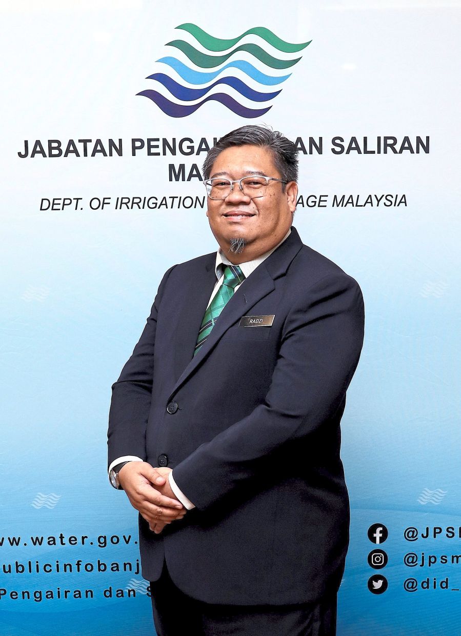

Mohamad Radzi: The DID project aims to address erosion, flooding in Pantai Cunang and Pantai Tanjung Sepat.
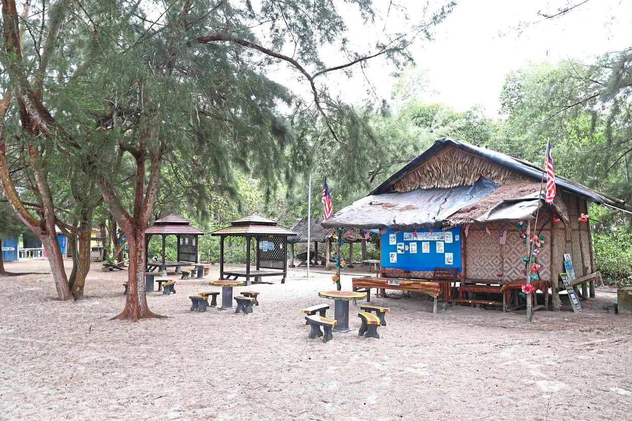
Pantai Cunang with its white sandy beach has a lot of tourism potential. But coastal erosion has caused considerable damage and puts visitors off.
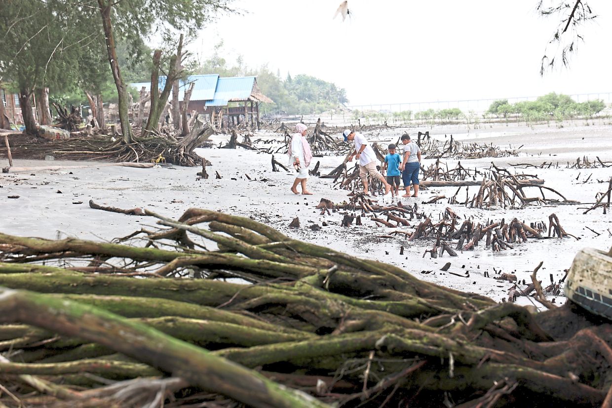
Casuarina trees, which once provided shade to visitors at Pantai Cunang, have uprooted due to strong winds and erosion. — Photos: ART CHEN/ The Star A family walking along Pantai Cunang which is strewn with exposed mangrove roots and fallen tree trunks.
DID is planning to build a wall to mitigate flooding in Pantai Cunang.
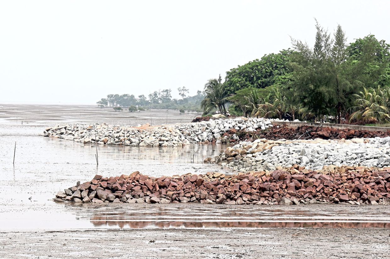
DID constructed a 220m rock revetment along the coastline in Pantai Tanjung Sepat.
Ahmad Aldrie is concerned about the effects the revetment wall will have on the mangroves.
Izham says the RM7.9mil project by DID is slated for completion in July 2026.
Mohamad Radzi says the DID project aims to address coastal erosion and flooding in Pantai Cunang and Pantai Tanjung Sepat.
Sarimah says that the villagers began noticing the changes in landscape a few years ago.


